
Very early mention of Australia.
JOUY, E. (Victor-Joseph Étienne de) (1764-1846). Pierre-François GODARD (illustrator). Sixième Jeu de Cartes Géographiques. Nouvelle Édition Revue et Correctée. Lille and Paris Chez Vana[ck]ere and Chez H. Nicolle. 1806 [1810]
£1,200.00
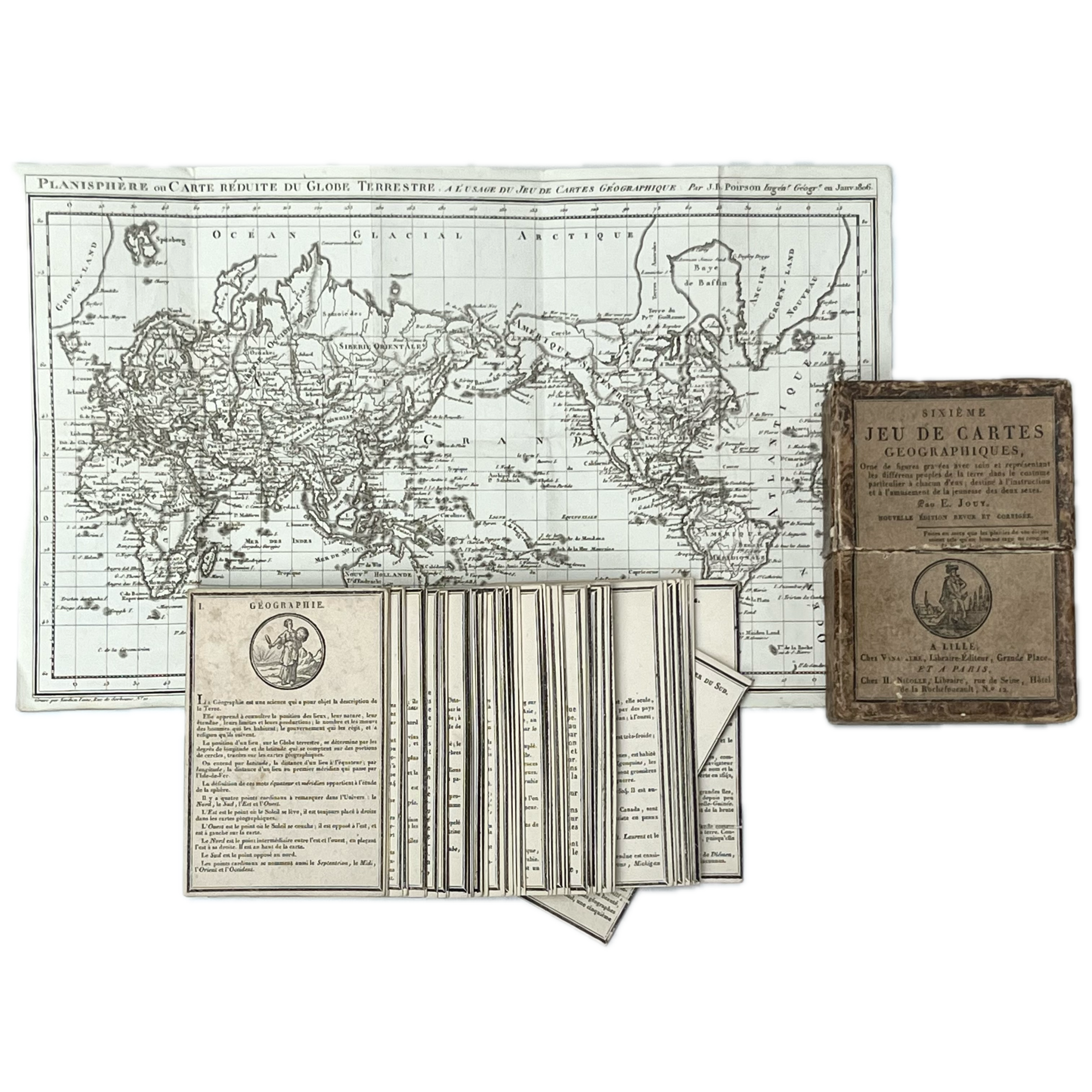
Original publisher’s card slipcase (11 x 7.8 x 3.2cm) decorated with marbled paper, with pasted printed paper label in letterpress with pictorial vignette, containing the complete suite of 48 cards, each numbered and engraved with a pictorial woodcut medallion by Pierre-François Godard, with substantial explanatory text beneath, each card depicting a different region including: Nouvelle-Hollande; Terres Polaries et Australes; Isles D’Afrique; Abissinie et Nubie; Barbarie; La Chine; La Terre etc., lacking the instruction sheet but, remarkably, with the usually absent accompanying folding copper-engraved map designed by J.B. Poirson housed in the case, this titled “Planisphère ou Carte réduite du Globe Terrestre”, and on laid paper, with watermark and printed date Janv. 1806, map dimensions 18.4 x 29.8cm; case soiled, rubbed, and dusted but remaining in remarkably good condition and, when the set is found, frequently absent; cards generally in excellent state with a little occasional spotting and minor signs of use, with horizontal crease to the lower edge of 2 cards; a remarkable survival.
In French. First issued in 1806, this is the revised and corrected edition of the work, published 4 years later.
Victor-Joseph Étienne (known as Étienne de Jouy, 1764-1846) was a famous librettist, dramatist, journalist and intrepid traveller who enjoyed a distinguished military career. During the French Revolution he was arrested and narrowly escaped execution for refusing to toast the revolutionary leader Jean-Paul Marat during the Reign of Terror. He later resigned his commission and moved on to safer ground in the field of literature penning the librettos for operas such as La Vestale by Spontini, writing plays including his tragedy Sylla ((1821), and contributing satirical sketches to periodicals. Between 1804 and 1821 he created about 15 educational text-heavy card games illustrated with woodcuts, which became very popular.
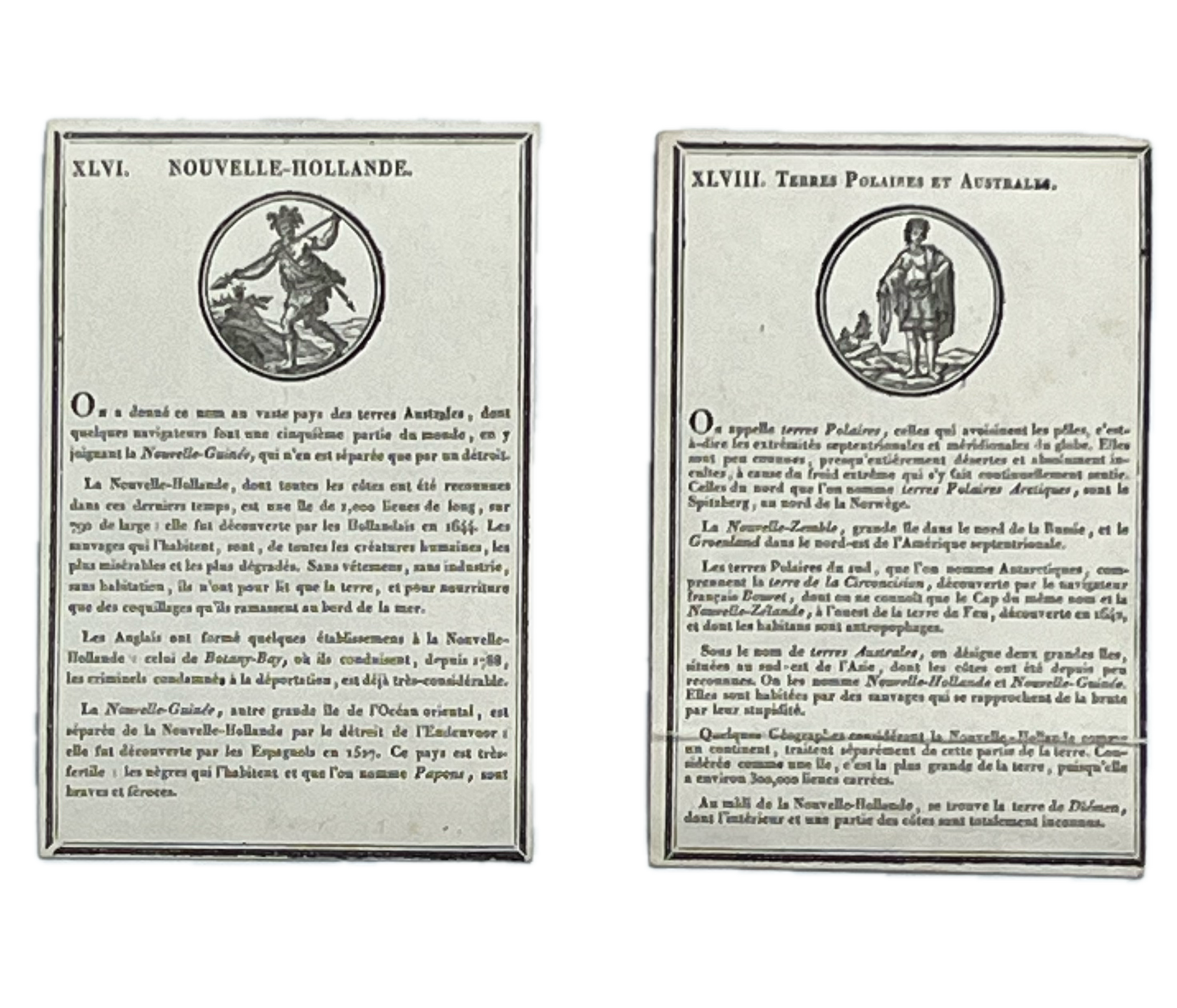
An important educational card game which is one of the first to feature Australasia and its people. Nouvelle-Hollande is represented by card XLVI, which also includes New Guinea, and depicts a warrior dressed in animal skins and head-dress, brandishing a spear, which interestingly is at variance with the card description, a translation of which details the Australian Aborigine as without clothing, without industry, and without habitation, with nothing to sleep on apart from the ground and nothing for nourishment except for shellfish which they gather at the edge of the ocean. They are also described as being the most miserable and degraded of all humans. Also referenced on the same card is the English settlement at Botany Bay, with mention made of the transportation of convicts.
Card XLVIII represents Terres Polaires et Australes and illustrates a bare-chested young woman. Printed text refers to New Zealand as inhabited by cannibals and describes the savages of New Guinea and New Holland as primitives, due to their poor intellect, “Some geographers consider New Hollande to be a continent… considered as an island, it is the largest on Earth, approximately 300,000 square leagues”. Very scarce. Six copies of the first 1806 edition located in institutional libraries worldwide of which only 1, at the Bibliothèque Nationale de France, appears complete with slipcase, instruction sheet and map; also held at John Carter Brown Library (without map); Toronto Public Library (lacking map); Princeton Public Library (lacking map), and at the State Library of Tasmania (lacking half of slipcase, several cards, sheet and map) and at Mediathèque Valais – Sion (possibly lacking slipcase and without sheet and map). Only 1 example of this 1810 corrected edition located, held at the National Library of Australia, in Canberra, but, according to the record on WorldCat, again lacking the map.
In stock
Related Products
-
![[Complete set of the "Adventure Books"] The Island of Adventure; The Castle of Adventure; The Valley of Adventure; The Sea of Adventure;The Mountain of Adventure; The Ship of Adventure; The Circus of Adventure and The River of Adventure.](https://www.rosiehodgebooks.co.uk/wp-content/uploads/2025/10/IMG_5025-600x473.png)
BLYTON, Enid (author). Stuart TRESILIAN (illustrator). [Complete set of the “Adventure Books”] The Island of Adventure; The Castle of Adventure; The Valley of Adventure; The Sea of Adventure;The Mountain of Adventure; The Ship of Adventure; The Circus of Adventure and The River of Adventure. London Macmillan & Co., Limited. 1944-1955
£3,000.00 -
[VENNING, Mary]. A Geographical Present Being Descriptions of the Principal Countries of The World: with Representations of the Various Inhabitants In Their Respective Costumes. Beautifully Coloured. London Printed for Darton, Harvey And Darton, Gracechurch-Street. 1817
£300.00 -
BURNETT, Frances Hodgson (author). Ethel Franklin BETTS (illustrator). A Little Princess, being the whole story of Sara Crewe now told for the first time. New York Charles Scribner’s Sons. 1905
£850.00 -

CARROLL, Lewis (author). Charles van SANDWYK (illustrator). Alice’s Adventures in Wonderland. London The Folio Society 2019 Signed
£350.00